Alta Via 2 - Italian Dolomites
- Aug 1, 2023
- 24 min read
Updated: Mar 17
7/22/2023 - 8/2/2023
Day 1: Brixen to Schlüterhütte/Rifugio Genova
Our trek began from the bus station in Brixen. With all our things packed, we used our Brixen cards to catch Bus 321 for free from the Busbahnhof (central bus station) to the base of the Plose gondola. Brixen cards are an awesome benefit of staying in town. Over 100 hotels/establishments participate, providing cards to guests that allow access to museums, ice rinks, pools, and, importantly, free travel on South Tyrol’s entire public transport network.

After a short ride uphill (only about 7 km), we got off at the base of the Plose gondola. The ability to take public transport right to the start of a long trek was incredible - the United States should take notes! Most of the other bus passengers were fellow hikers or gondola-riders. There were many people with backpacks and trekking poles ready to start longer treks like Alta Via 2 or simply taking a ride up the gondola for a day of hiking, sight-seeing, or mountain biking.
It is certainly possible to start AV2 by hiking up from the base of Plose, but a gondola ride is included in the Brixen card for free. Saving over 3000 feet of gain at the start of our trek was a no-brainer for us. Plus, the gondola brought us directly up into the alpine, meaning we would start our walk with dramatic views of the Dolomites from the first step.
There are many ways to complete Alta Via 2. We chose a 12-day itinerary with stays at various mountain huts (refugios) and hotels along the way. Schlüterhütte (aka Rifugio Genova) was a logical first stop for us on night 1, which meant we had to travel over 10 miles from the top of the gondola. The trek began under inauspicious skies, the clouds were dark and we got a few raindrops, which prompted us to break out our pack covers right away. The lowlands of Italy were experiencing a record-breaking heat wave, which in turn was creating unsettled weather in the mountains. We were hopeful the cloudy, rainy weather wouldn’t be too much of a pattern for us on our trek.

Despite the weather, AV2 was instantly beautiful. We were hiking through grassy meadows with peacefully grazing cows and were treated to distant views of some quintessential rugged Dolomite peaks and cliffs. The cows all had big brass bells around their necks, which meant we were sometimes surrounded by the whimsical tinkling of bells as we were walking.
After 1.7 miles and 1330’ feet of gain we passed Rifugio Plose. This was our first mountain hut experience in the Dolomites and it was fun to sit down and have a snack. We could get used to this lifestyle!
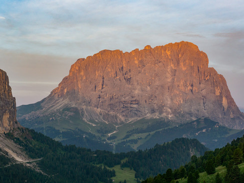
The next section of trail was a 3.7-mile, 2000-foot descent to Passo Rodella. We were treated to some sunbreaks and great views of Peitlerkofel during this descent.
At the pass, we had to change gears and climb back up to Peitlerscharte. This involved about three quarters of a mile of road-walking before we hopped on another well-marked trail that began climbing up to the pass. The path became fairly steep as we ascended out of the forest and back into the grassy subalpine. By the time we reached the pass, the weather had changed again, and we were socked in by clouds and wind. Eager to get out of the elements, we cruised the final 1.3 miles of nearly flat trail into Schlüterhütte.


This hut was a delight and served as a cozy refuge for us. Its style felt much more German than Italian. The food menu included Tyrolean fare like dumplings, speck, and other hearty mountain dishes, mixed in with Italian influences like pasta. It was all delicious and it was fun to mingle with other hikers from around the world. Prices for staying in the mountain huts varied throughout our trek but were never particularly cheap. For instance, a bed with bedding and breakfast at Schlüterhütte costs 54€ per person per night as of 2026. Still, it was a very unique experience, and something I highly recommend if your budget allows.


Final Stats: 10.1 miles / 3069 feet of ascent / 2158 feet of descent / 5 hours and 35 minutes

Day 2: Schlüterhütte/Rifugio Genova to Gardena Pass
I began day 2 of our AV2 trek with an early morning ascent of Zendleserkofel, a peak that sits directly above Schlüterhütte. It was a short half mile ascent from the hut on an easy trail, providing great views of the surrounding peaks bathed in the morning light.


Returning to the hut, Katie and I had breakfast, which, as was the case at most huts in the Dolomites, consisted of bread and jam and other light fare. If pursuing more strenuous hiking objectives, I would recommend bringing some extra breakfast items or granola bars to supplement the hut offerings.

The day’s trekking started on relatively flat trail, which contoured through more beautiful meadows of vibrant green. After three miles of walking, we began a more rugged ascent up to Forcella della Roa. The trail switchbacked through scree to reach the beautiful pass. The views as we approached the pass were the most dramatic we had seen yet, with the spires of the Piz Duleda group towering above narrow notch in the ridgeline.


After reaching the pass it was time for our first via ferrata experience! This easy via ferrata can be bypassed with some extra hiking, but Katie and I were excited to put our gear to the test. It was a very fun experience to clip into the various bars, rungs, and cables that guided us up for two or three hundred feet to gain a ridgeline above. We quickly got into a rhythm clipping and unclipping the carabiners efficiently.

After successfully topping out, we had another 2 miles and 1100 feet of descent before reaching the Puez hut. Many people who set out on AV2 use Puez as a logical end point of their second day. We had initially tried to reserve a room here, but they had been completely booked months in advance! When in doubt, it is key to book early. Regardless, we had a great pasta lunch with spectacular views and were very content to kick back and relax for a bit and enjoy the ambience of the outdoor seating. Plenty of other folks were doing the same, as the hut is a reasonable day hike distance from Gardena Pass – our future end point for the day.
The 4.2 miles beyond Puez were quite enjoyable. There were some ups and downs and more great views, including the jagged rock formations we hiked through near Furcela del Cir. By the time we strolled into Gardena Pass, the miles had added up, and we were both feeling a bit worked by the longer day but were overall thrilled with the spectacular scenery and fun via ferrata during the day’s adventures. Gardena Pass is situated on the SS243 highway, so it was interesting to see sports cars cruising the windy road after 2 days off the grid. We stayed the night at Rifugio Frara, which doubles as a hotel right off the highway at the pass.

Everything was excellent at Frara except for some potentially expired wine that had a distinct carbonated character. I drank it anyway in my jetlagged haze, expired wine can’t hurt you, right??
Final Stats: 11.6 miles / 2832 feet of ascent / 3486 feet of descent / 7 hours and 29 minutes

Day 3: Gardena Pass to Rifugio Pisciadu
Day 3 was set up to be our shortest day on the trek. Due to our long day 2 making it all the way to Gardena Pass, a short but steep climb to Pisciadu was the only thing scheduled for the day. There are two ways to Pisciadu from the pass – either on the standard AV2 route, or via the sporty Via Ferrata Brigata Tridentina.


After our first use of the via ferrata gear the day before, Katie and I were both excited to try out a harder route. Via Ferrata Brigata Tridentina seemed to fit the bill. It is rated as difficult and one of the most popular ferrata routes in the Dolomites.
After a spectacular sunrise and breakfast at Frara (more bread and jam), we set off toward the start of the route. The trail climbed up from the pass before it contoured to the east and then lost a bit of elevation to reach the starting point, which was about 1.3 miles from Gardena Pass.
On the way, we saw some ominous clouds building in the distance and the once brilliant blue sky began darkening above us. We ran into a guided group at this point, and the guide flatly asked us, “You know about the rain, right?”. To this, we earnestly answered that no, we did not… Normally on my adventures in the Cascades I’m very on top of the weather and will religiously check forecasts before heading out. On this trip, however, getting over jet lag and adjusting to a new part of the world, I hadn’t been checking as zealously. The guide even pulled up the weather radar on his phone to show us and indeed, there was a blob of precipitation heading towards us.
There was arguably still time to complete the via ferrata before the weather was predicted to arrive, and after going back and forth, we decided (perhaps foolishly) to give it a shot. We got into our gear and made it about 20 feet off the ground before we began to feel drops of rain hitting us. It seemed as if the precipitation had come early and we knew that a more difficult via ferrata was not a place to be when the rocky surfaces were slick there. There was no doubt that we should turn back. We reversed course and gingerly downclimbed the few rocky steps and iron rungs that we had climbed with our tails between our legs.

We swallowed our pride and beat a retreat to the standard ascent route to Pisciadu, climbing back up the trail we had just descended in a light rain. The main route climbs steeply up a canyon, first in rocky switchbacks and then transitioning to some easy via ferrata up high. We were in a misty rain for most of the switchbacks (thankfully it never got too wet), with clouds swirling through the rugged peaks and canyon walls that surrounded us. It was a moody atmosphere. The final via ferrata moves were quite fun, and it wasn’t long before we popped out onto the flat plateau that Pisciadu is situated on.
Pisciadu was another cozy mountain hut, and we happily hunkered down there, enjoying the customary pasta and wine that we were already getting used to. That night it rained hard, and we were thankful not to be out in a tent. Instead, we got to share the experience with 30 or so fellow travelers in the dormitory.
It was a short day on paper (in the end we had only gone about a mile and a half), but with the weather-related via ferrata failure and battling the elements it still felt like a big day.

Final Stats: 1.7 miles / 1720 feet of gain / 187 feet of descent / 1 hour and 57 minutes (not including Brigata Tridentina attempt)

Day 4: Rifugio Pisciadu to Rifugio Marmolada Castiglioni
We were set to have a more “normal” day on the trail on day 4, with the end goal being Rifugio Marmolada, some 9 miles away. Thankfully, the rain had stopped overnight, and the sun was shining as we set out from the cozy confines of Pisciadu.

Almost immediately after passing Lake Pisciadu there were some rocky steps and ledges with cables to clip into. Most people simply used the cables as a handline in this location. We bypassed the short scramble up to Cima Pisciadu, which I’m sure would be worthwhile, instead marching on to a pass with great views of rugged cliff faces and the distant peaks and valleys that we had hiked through in the preceding days.

Beyond this point, it felt like we were hiking on the moon. The terrain was barren, rocky, and had a distinctly lunar flair as we passed Rifugio Boe. We toyed with the idea of hiking up to Piz Boe, the tallest peak in the immediate area, complete with its own hut directly on the summit, but instead chose to continue in the direction of Rifugio Forcella Pordoi.
At Forcella Pordoi, AV2 hikers are presented with two options, either losing a knee-rattling 2000 feet in 1.4 miles or taking a gondola down after making a quick ascent to Sass Pordoi. Despite the cost of 17 euros per person, this was an easy decision for us, and we opted to take the short and scenic ride down to Passo Pordoi.
At the pass we were once again thrust into polite society, mingling with the many tourists who had made the scenic drive up and over the pass. We popped into a restaurant for lunch before continuing in the direction of Marmolada.
The trail after the pass was very scenic. It mostly made a long side-hilling traverse through open grassy meadows. The vivid greens of the grasses we were hiking through now provided quite a sharp contrast to the moonscape we had just experienced under Piz Boe.

We stopped briefly at Rifugio Viel dal Pan to say hi to some friends we had made on the trail and to offload some of our shampoo and conditioner on them, which made for a funny scene as we squirted the liquids directly into glass cups. Pro-tip: don’t carry full bottles of shampoo and conditioner on AV2 like we did.

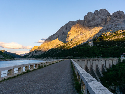
After this short break, we resumed our descent to Rifugio Marmolada Castiglioni, losing almost 1400’ of elevation in the process. This hut was a dramatic one, situated on the shores of the manmade Lago di Fedaia and at the base of Marmolada, the tallest peak in this part of the Dolomites. Marmolada’s glaciers had been a focal point of our view as we traversed eastward from Passo Pordoi. At the hut we enjoyed the sunset and settled in for a night of cards and Aperol spritzes.

Final Stats: 10.1 miles / 2748 feet of ascent / 4493 feet of descent (including gondola ride) / 6 hours and 30 minutes

Day 5: Rest Day + Via Ferrata della Trincee/Cima Mesolina Loop

This was our only planned rest day of the trek, and I started it off in a decidedly un-restful manner - by attempting Via Ferrata Delle Trincee. I set off in the morning on a steep trail directly from Castiglioni, climbing toward the futuristic-looking Rifugio Luigi Gorza. After striking out on Via Ferrata Brigata Tridentina earlier in the trek, I was eager to try a more advanced via ferrata.
After about 1800 feet of steep trail, I finally found myself at the base of the ferrata route. The beginning part ascended an impressive rock face that was part of Cima Mesola - it looked steep and challenging. I was up to give it a go, but much to my dismay, there was a significant lineup of folks waiting to get on the route. After waiting around a bit and observing just how slowly these groups were moving, I decided it wasn’t worth being away for too long, so I made the last second decision to see if I could bypass the start of the loop and still complete most of the route I had planned.

After a bit of exploration, it became clear that I could easily rejoin the route with just a bit of class 2/3 scrambling. I was bummed to miss out on another cool via ferrata experience, but happy to have not struck out completely.

The rest of the eastward traverse involved some traverses on dramatically exposed cliffs, which made me thankful for the cables I was able to clip into. There were a few sections of more vertical climbing and downclimbing, which were a blast and gave me a taste of what I might have missed out on earlier.

On the far eastern side of the ridge, I encountered a network of tunnels that had been carved directly into the mountainside. Many of them went straight through the ridge connecting the two sides, and some had branches and forks that gave me some pause as I was exploring…it could be easy to get lost! It was pretty fascinating to imagine soldiers in these tunnels during wartime.
Eventually I popped out of the tunnels at the Bontadino Bivouac shelter and decided to dash up Cima Mesolina while I was there. The short but steep 250-foot climb brought me up to a summit that had great views of the ridge I had just traversed.
There are multiple options to traverse back to Castiglioni from the end of the ridge. Thanks to my friend Jim’s excellent trip report ____, I knew not to be tempted by the most direct way down, as he found it to be steep and sketchy. Instead, I stayed on one of the higher trails (the middle one marked on maps at about 2400m) and it proved to be a pleasant route across the grassy hillside. I eventually joined up with the trail I had taken up from the lake in the morning. The final descent was steep but straightforward and I saw a massive herd of sheep traversing the open meadows above me.


Overall, the loop took me a little over 4 hours, although I suspect it would have taken much longer if I did the full Trincee ferrata.
We enjoyed the rest of the day eating pizza, walking across the Lago di Fedaia dam to the tiny community on the other side, and watching the last rays of sun bathe Marmolada in golden light. We were excited to continue our trek the next day.


Final Stats: 6.7 miles / 2788 feet of ascent / 2774 feet of descent / 4 hours and 11 minutes

Day 6: Rifugio Marmolada Castiglioni to Passo San Pellegrino
We were back to our regularly scheduled programming today…mostly. AV2 trekkers are presented with multiple choices when heading south from Castiglioni hut. The options we were weighing regarded circumnavigating Marmolada to reach the town of Malga Ciapela. Hikers can do this either on foot, by a combination of trail and road walking, or by taking a shuttle. Either way, we would need to lose about 2000 feet of elevation over 5 miles. The previous night, the proprietors of Castiglioni hut came around and asked the guests if they would like to take the shuttle the following morning for a few euros. Most everyone did, and Katie and I were no exception. It seemed like a no-brainer to skip the downhill in a mostly forested valley to help us return to the alpine quicker.
We hopped in the van in the morning with several other groups and proceeded down some super tight switchbacks, reaching the little town of Malga Ciapela in no time. We were dropped off at the base of a gondola and were back to foot-powered transport as we began a climb up to the pass called Forca Rossa.
The first bit of walking was still in the valley on a paved road. Katie was delighted to see the farm animals (especially the donkeys) in the little road-side paddocks and made sure to greet them all. Asphalt soon gave way to gravel, and we began climbing in earnest. Gravel road in turn gave way to normal hiking trail, and we slogged up the final switchbacks to the pass. We took a well-earned break here after gaining over 3300’. This felt like the biggest uphill push of the trek so far.

Beyond the pass, we descended into open, meadowy bowls complete with free-roaming horses. One particularly cute mare and foal were a highlight of this section as they got quite close to us. We then dropped further still to Refugio Fuciade for lunch.

Refugio Fuciade was a sight to see, it seemed like half of northern Italy was out enjoying the beautiful day. We noticed that an especially large number of people out were families with young children that were picnicking and having lunch. I was very impressed that so many people, young and old, had made the 5-mile round trip walk to this location. We put out our towels and had a very relaxed time laying out in the grass and watching the world go by.

Eventually we had to tear ourselves away from the idyllic scene and march those 2.5 miles to Passo San Pelligrino (is this where the sparkling water comes from??). We stayed in a more traditional hotel here and were greeted by a hotel manager who had a charming twinkle in his eye. Katie and I still remember him fondly. We settled in and took advantage of the extra daylight hours by washing some of our hiking clothes and socks in the sink and hanging them out to dry on the line outside. We enjoyed a nice dinner at the hotel and thought about how this hotel and area would be fun to come back to for ski season sometime.
Final Stats: 9.4 miles (not including shuttle ride) / 3420 feet of ascent / 1932 feet of descent / 5 hours and 19 minutes

Day 7: Passo San Pellegrino to Rifugio Mulaz
We set off from Passo San Pellegrino, sad to leave our friendly innkeeper, but excited for what lay ahead of us on the southern part of the trek. The southern part was rumored to be a bit rougher and less traveled than the north, and we immediately found that to be the case by setting off on the wrong path from the pass. We quickly corrected our mistake and found our way through the confusing maze of trails to the actual AV2 path.
We then climbed up and through a ski area before arriving at another pass – Passo Valles. Here we had an espresso and pastry (Italy things) before setting off toward Mulaz. This climb initially followed a ridgeline with expansive views of rugged peaks. The biggest excitement came at one point where we had to be careful not to get run over by a herd of cows being driven from one meadow to another.
The trail then curved south and began a steep ascent toward Mulaz. There were occasional cables to use as handrails in this section, and we could see impressive cliff-faces towering above us. This was probably the most rugged section of trail we had encountered yet on AV2. We reached Mulaz Hut eventually and found it to be in an extremely impressive location nestled under Passo Mulaz and the towering cliffs.


We had dinner and played cards with our trekking buddies who we were quickly getting to know. We also made the short climb up to the pass to watch sunset - I loved seeing the alpenglow hitting the peaks.


Final Stats: 9.4 miles / 3323 feet of ascent / 1233 feet of descent / 5 hours and 30 minutes

Day 8: Rifugio Mulaz to Rifugio Rosetta
I woke up early to catch sunrise from Monte Mulaz, leaving the hut before dawn and trying not to wake anyone in the process. There is a marked path all the way to the top, with some minor exposure in a few places. It was easy to navigate, and I found myself on the crucifix-adorned summit less than 30 minutes after leaving the Refugio. It was an unbelievable place to see the sunrise, looking out on the sea of peaks and ridges that make up the Dolomites. After the sun came up officially, I scurried back to the hut for breakfast, ready for a fun day on AV2.


AV2 got down to business quickly, and we soon found ourselves putting on our harnesses to go up and over Passo delle Farangole. This section felt a little more like a “real” via ferrata, with iron rungs, ladders and cables to assist with the steep terrain. We both had a blast and were sad when it was over.


Beyond the pass, we made a steep descent before leveling out to traverse past Cima Comelle. Katie and I both found this section to be tougher mentally than physically. We were hiking through a sloping meadow, which was pleasant enough, but only a few feet away from the trail the ground gave way to 1000+ foot cliffs. There was an occasional cable to clip into, but much of this section was devoid of any protection, which made it more mentally taxing than it should have been. I found myself subconsciously leaning into the slope and we were both happy when the terrain eased.

Beyond the cliffy traverse we found ourselves in a similar lunar landscape that reminded us of the area under Piz Boe. This made for interesting hiking as clouds were beginning to move in and obscure the once brilliant blue sky. We made a final climb of about 800 vertical feet to Rifugio Rosetta, reaching it only four and a half hours after leaving Mulaz. We were there early in the day, but the weather had shifted and we were completely socked in by cloud, so we spent the day hunkered down with our hiking buddies (and some clean and well-dressed tourists who had taken the gondola up from San Martino di Castrozza).

Final Stats: 5.1 miles / 2310 feet of ascent / 2305 feet of descent / 4 hours and 39 minutes

Day 9: Rifugio Rosetta to Rifugio Treviso
I woke up early again for another sunrise ascent of an easy peak – this time my objective was Cima della Rosetta, a mountain that rises gently to the west of the hut that shares its name. It was an easy hike that gained a little over 300 feet in two-thirds of a mile, and it brought me up to another crucifix adorned summit. It was an awesome place to catch the sunrise.


After breakfast, we packed up and prepped for what would be one of the most physically demanding days of the trek. We immediately descended a series of steep rocky switchbacks before beginning a traverse to Passo di Ball. We were joined by our friend Tim (a fellow hiker from Australia), and we all enjoyed the incredible views of steep and rugged peaks in this area. On the way to the pass, the trail began to narrow and eventually turned into a tiny ledge in the middle of a good-sized cliff. Thankfully, there were horizontal cables throughout this section. We had a lot of fun navigating the exposed path and were all exhilarated when we reached the other side.


Beyond the pass, we made a short descent to Rifugio Pradidali and then set off into another moonscape, this time with rugged cliffs soaring above us. It was a spectacular setting. Another series of via ferrata cables and iron rungs brought us up to Passo delle Lede, where we enjoyed the awesome views of the sheer dolomite rock faces behind us.


Now began the “fun” part of the day – a knee-rattling 4000-foot descent into the Torrente Canali valley. The grade was gradual as we began but soon steepened as we paralleled a small creek near tree line. It felt like the first time we were seeing proper trees up close since Passo San Pellegrino – it had been quite the extended period above tree line! Another highlight of this intermediate zone between the alpine and forest was seeing several edelweiss flowers.

Eventually we were fully in the woods and found the trail to be slippery in places. I took one particularly funny banana-peel-type fall on a muddy patch but hopped up unscathed.
We crossed the creek in the valley floor and, to add insult to injury, had to gain 500 feet on the opposite hillside to reach Rifugio Treviso. It was hard to shift gears at the end of a long day after 4000 feet of descent, but we eventually made it and were happy to shed our packs and put our feet up at the end of the day. This was the hut where Katie learned you could order prosecco at the mountain huts, which was a fun treat. It was also where we overheard Tim facetiming his wife back in Australia saying that he had “crashed a honeymoon” …after which we popped our heads into the frame to reveal the lucky couple to her.

Final Stats: 8.2 miles / 2430 feet of ascent / 5574 feet of descent / 7 hours and 15 minutes

Day 10: Refugio Treviso to Rifugio Cereda
Day 10 started cloudy as we began a gently rising traverse from Treviso. Our gentle warmup ended in a hurry, however, because after a mile or so, we hit a trail intersection and began a straight-up climb to Forcella d’Oltro. This climb felt hard after our big effort the previous day and we were thankful for the cloudy weather.

Beyond the pass, the trail was much easier. It made a high traverse below a ridgeline, and despite gaining another 700 feet or so after the pass, the grade was quite gradual. We enjoyed the scenery through here; it was very green and consisted of lush meadows dotted with rocky cliffs and spires. Combined with the misty cloudy weather, it made for a very dramatic landscape.

We again had a steep descent to our home for the night. We dropped over 2500’ to Passo Cereda, which felt harder than it should have – a pattern that was emerging for us as we neared the end of the trek. We ran into Tim again at the terminus of the steep trail and the three of us limped into Cereda on a gentle path, all feeling worked by the short but deceptively difficult day.

Rifugio Cereda is more of a traditional hotel, and it was here that we had a big dinner with our fellow hikers that we had fallen in with the past couple of days. We had met a nice community of people from around the world, and we enjoyed swapping stories from the trail and from our homelands. The social aspect of the trek was an unexpected benefit of AV2 for me.


Final Stats: 5.6 miles / 2364 feet of ascent / 3214 feet of descent / 5 hours and 4 minutes

Day 11: Rifugio Cereda to Rifugio Boz
It was hard to believe this was the second to last day on AV2. The day dawned cloudy again and the threat of rain was real. After the initial few days, we had had awesome luck with the weather, so it was only right that we had at least one day with a questionable forecast.
Katie and I set off alone, hiking fast and hoping to beat any rain that came our way. From Passo Cereda, AV2 bears east and is quite flat until it begins a steep climb up to Passo del Comedon. We cruised on the flat part and then began our ascent into a rocky, cliffy area below the pass. It was here that a soaking rain started, and we donned our raincoats that had been on the bottom of the pack for several days.
The rainfall increased in intensity, and we didn’t love the idea of getting soaked and cold, so we found a very well-placed overhanging ledge to hide from the rain under, sharing our dry space with another intrepid hiker that came along.
We watched the rain come down hard and were very thankful for our shelter. We hoped all our friends were also able to get out of the deluge!
Eventually the rain let up, and we deemed it dry enough to continue. We crested the pass and made a descent back into green meadows, passing Bivacco Walter Bodo in the process. Even though the rain had stopped, all the grass was soaked.

The traverse to Boz was one of the only times on the whole trek where we more or less put our heads down and powered out the miles. The misty clouds didn’t allow for much in the way of views, and the thought of getting our feet dry at the next hut was appealing.
There were still several cool parts of this section. Partly because I was keeping my head down more than usual, I was able to spot a fossilized shell embedded in the rock at my feet. This was a good reminder that the Dolomites were once under a shallow sea. There was another awesome section where the trail traversed past several small waterfalls pouring off a rock face, their flows undoubtedly increased by the recent rain.
The final half mile from Passo di Mura to Rifugio Boz was almost comically muddy and slippery. It was all we could do to stay on our feet as we surfed down the slick hillside to safety at the mountain hut.
Gradually, all our fellow hikers trickled in, sharing their own war stories of rain and mud. Everyone had a lot of trouble with the final descent! The night was spent getting warm and dry, drinking wine, and watching the clouds part right at sunset, before we settled in for our last sleep on the trail.

Final Stats: 8.8 miles / 3806 feet of ascent / 2644 feet of descent / 6 hours and 7 minutes

Day 12: Rifugio Boz to Croce d’Aune
The final day of the trek had come – it was a bittersweet moment. We set off as a group with the hikers we had spent the most time with (most of which had been traveling on the exact same itinerary as us from at least Mulaz, and some before that). It was fun to see the community that we had built in such a short time on the trail, and sad to think about the likelihood that we would never see any of them again after finishing AV2.
AV2 didn’t go out with a whimper, because there were still some exposed via ferrata sections to be dealt with. Everyone did great on these, and there was another sad moment as we put our harnesses away for the last time.


The last day was no slouch mileage-wise, and mostly cloudy again, so there were some uneventful miles before arriving at the last hut of the trip, Rifugio Giorgio dal Piaz, for a late lunch.
Beyond this point, all there was to do was to drop out of the alpine and back to civilization. The “official” end of AV2 is in the town of Feltre, but most people we talked to were ending in the village of Croce d’Aune. A taxi ride to Feltre saves several miles of road walking.
After another steep descent, we finally burst out of the woods in Croce d’Aune with our friends Mike and Suzie. I’m not sure what I was expecting, but Croce d’Aune was much smaller than I had anticipated and there was absolutely no fanfare regarding the end of a world-famous trek. I had figured it would be easy to call a taxi, but that was not the case. The four of us ended up wandering around the town, and a restaurant owner who spoke no English was kind enough to help us. Using a combination of hand gestures and some Italian words, Mike was eventually able to communicate that we needed to call a taxi to Feltre. The family that owned the shop was so nice and helpful, and eventually the owner’s son came by to give us a ride into town. He spoke great English and we were all grateful he went out of his way to help us.

We were eventually dropped off in Feltre, said goodbye to Mike and Suzie, and checked in to our hotel. We got clean and at dinner were already reminiscing about the awesome hike, the amazing scenery we had seen, and the good friends we had made along the way.


Final Stats: 13.0 miles / 2949 feet of ascent / 5111 feet of descent / 7 hours and 39 minutes


Comments