Big Snagtooth
- May 31, 2025
- 3 min read
Updated: Dec 16, 2025
5/31/2025
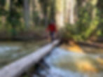
Brad and I set off to summit the high point of Snagtooth Ridge – Big Snagtooth – starting from the same pullout on the side of Highway 20 that I used to climb Silver Star Mountain via Burgundy col. We immediately dropped down to the river on the familiar junky climber’s path, losing 200 or so feet in the process. We wandered around a bit off trail to find a suitable place to cross the creek, eventually finding a nice log to shimmy our way across.
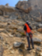
The Early Winters trail was in fairly good condition and was easier to follow than I expected, but we didn’t stay on it long, starting our plunge into the forest at around 4200’. We did a bit of brush bashing here and there as we battled our way up Willow Creek, always staying a good distance north of its banks.
At one point we got suckered into following the creek at around 5500’ and encountered the worst brush of the day. After some character-building thrashing, we emerged on the high side the of the creek into much less dense undergrowth. Trees started to thin as we quickly gained elevation, and patchy snow began to appear around 6700’.

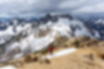
We entered the fully snow-covered upper basin at 7000’ and enjoyed some awesome views up towards Snagtooth Ridge and back in the direction of Highway 20. To gain the west ridge, we got the ice axes out and made a semi-steep snow climb to surmount the ridge. I’ve heard this section can be horribly loose later in the year, so we were happy to do it with snow cover.

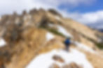
The west ridge itself was almost entirely snow free, so we began the easy slog up to the summit block. The weather was forecast to change in the early afternoon, and like clockwork, clouds had begun to gather in the west and the wind was kicking up.

We still had enough time to tag the summit, so we quickly got out the rope and our rock shoes. Big Snagtooth has two main difficulties, a 50-foot section of class 4 or low class 5 and final summit boulder that is rated at about 5.7 for one move. Brad was comfortably simply scrambling up the first chimney-type feature and then belayed me up.
A bit of light scrambling then brought us to the final summit slab. Some parties opt to do a shoulder stand, where one person boosts the other on their shoulders up above the most difficult move, but Brad was able to pull it off with a bit of searching for the best holds. Exposure is not too great here, but a fall would certainly hurt. I was able to handle the move pretty easily on top rope, and before you know it, we were both at the summit!

The weather was changing rapidly at this point, and clouds were whipping in at summit level. There was a bolt in the summit slab that was solid, so we used it to rappel off.
The second rap station was a mess of webbing and cordelette, which plenty of new material that we felt good about it. I went down first into the teeth of the gale and got a pretty funny video of Brad coming down with gray mist absolutely whipping past him as he made his descent. It was cold!
We had read a trip report about some pesky ravens that had gotten into someone’s pack in this area, but figured that the poor, windy weather would scare them off. This was sadly not the case, as we came back to our stuff and found that one of them had chewed a hole through Brad’s pack and stolen some of his snacks. Lame!

Despite that, the climbing had gone well, and we were eager to make a hasty retreat out of the alpine. We descended the way we came, making a fun glissade down into the upper basin once the slope angle eased.

On the way out we more or less followed our up track, except for some shenanigans as we attempted to rejoin the Early Winters trail. Eventually we were able to locate the trail, cross the river, and make the final punishing climb up to the highway, returning 9 hours and 50 minutes after we left it. Thanks, Brad, for the great day out and for belaying me on the summit block!

Final Stats: 7.5 miles / 4591 feet of gain
