Gannett Peak, WY
- Jul 3, 2025
- 9 min read
Updated: Feb 1
6/29/2025 - 7/3/2025
Introduction
Gannett is a big undertaking, no matter how you approach it. At 13,810 feet in elevation with over 7000 feet of prominence, it is an imposing, isolated mountain, in one of the most remote wilderness areas in the lower 48.
There are two main approaches climbers use to reach Gannett, one from the east and one from the west. The approach from the west (Pinedale, WY) is via the beautiful Titcomb Basin and requires going up and over Bonney Pass on summit day. This approach requires less mileage and total elevation gain than the other standard approach, but the longer and more difficult summit day can negate those advantages. The other main approach is from the east (Dubois, WY) via the Glacier Trail. This route is over 50 miles roundtrip with over 10,000 feet of elevation gain but has an easier summit day.
Alternatively, climbers can cut off mileage and gain from the east by going with a guide or working directly with the reservation to organize transportation through the Wind River Reservation.
After analyzing all our options, and factoring in that we had a failed attempt the year before, my dad and I decided that we wanted to eliminate as many variables as possible from our trip. We decided to go on a guided trip with Montana Alpine Guides and were glad we did! This way, we could use the third approach that cuts off significant distance, joining the Glacier Trail much closer to the peak, and have guides to cut out the mental load of a big trip.
We coordinated with the folks living on the Wind River Reservation that do all the transportation through their land to the Cold Springs Trailhead. This is not the most economical way to approach Gannett, but to us it was worth it. Plus, the ride in is an experience in and of itself.
Day 1: Cold Springs Trailhead to Upper Echo Lake
We woke up early in Dubois, which is a fun, outdoorsy town, and drove the 30 minutes north to the tiny outpost of Crowheart on the Wind River Reservation. There is nothing there except a gas station and a post office, and we met our guide Jake and porter Oskar promptly at 7. We could immediately tell that these were great guys who we would enjoy spending a few days in the wilderness with. Jake grew up a few blocks down from where I currently live in Seattle – small world!
After packing and sorting our gear (my pack weighed in at just over 50 pounds), we popped over next door to the home of the family that does all the transportation up to Cold Springs. Here, we loaded up the truck and my dad and I chose to sit in the very back on bench seating in the truck bed.
The nearly 12-mile road in to the Cold Springs Trailhead is quite an adventure. It gains over 3300’ feet up from the dry valley below through scrubland and cattle pastures. The cows will sometimes have to scurry out of the way of the approaching vehicle; they are all over the hillsides in this area. Also, this is a high-clearance required road. There were some dry streambeds that were filled with bowling ball sized rocks and I would cringe every time we drove over them. Even if it was allowed, there is no way I would take my car up this road! Our driver handled the road perfectly, as to be expected from someone who has driven it hundreds of times in their life.

Eventually we were dropped off at the trailhead, which was an informal grassy area with good views back east down to Crowheart far below. It is a surreal feeling to be dropped off and left somewhere. We cached some food and water for our return and made some final preparations before shouldering our heavy packs and starting out.
About a mile in, we reached a trail intersection. Here, we turned right and began a gradual 2000 foot climb up to Scenic Pass. The climb went well, and we were entertained by Oskar enlightening us about the various types of pine trees we saw.
Scenic Pass is a stark and treeless place – not a spot to be in a thunderstorm. It was a great place to catch a quick breather before making our descent toward Echo Lakes. Upon rounding the corner at Scenic Pass and heading southwest, Gannett Peak began to appear in the distance, looking imposing and still very far away.
The rest of the hike in was uneventful. We reached Echo Lakes and contemplated going the extra mile and half to Dinwoody Creek, but decided we liked the looks of camp at Upper Echo Lake. Plus, we figured the mosquitos would be slightly better out of the saturated river valley. We were partly right on this, but they were still pretty voracious in the evening.


We enjoyed a nice evening at camp, with a swim in the lake, and Jake and Oskar even brought us a charcuterie board complete with smoked salmon and cheese. This felt almost too luxurious, but I allowed myself to get comfortable with being a client on this trip and really enjoyed the gold star treatment we were getting. Thanks, Jake and Oskar! The entirety of the hike in from Cold Springs took about 4 and 40 minutes, and we felt great about the position we were in going into day 2.
Day 2: Upper Echo Lake to High Camp
We were moving again at 8:30 the next morning, making an 800-foot drop into the Dinwoody Creek valley to join the Glacier Trail. This valley was absolutely stunning. The turquoise ribbon of the creek meandered through a bright green valley with the glacier guarded upper reaches of Gannet Peak looming above. As an added bonus, the hiking was flat through this valley, so it provided a lot of opportunities to savor the beauty.


The only difficulties in the valley were a few creek crossings. The crossing of Klondike Creek necessitated taking off our shoes and wading through the icy water, and the crux creek crossing of Gannett Creek was easily dispatched by a narrow log crossing.


We then switchbacked up an additional 550 feet to reach our high camp at 10,600’. We only crossed a few snow patches in this section and camped at what seemed like the final trees in the area. They were stunted and wind warped but provided a bit of protection from the elements.
We got busy setting up our tents, and my dad even swam in the icy blue waters of the creek that was spilling out of a glacier not far from our camp. After another delicious dinner prepared by our guides, we talked strategy for the day to come. The weather seemed stable in the morning, and we were all systems go for an early start.

We went to bed early that night, hoping to scrounge out what little sleep our bodies would allow with pre-climb nerves and the knowledge that an early alarm clock was in our future.
Day 3: Summit Day
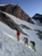
Summit day was here, and we got up way before the crack of dawn, blearily putting on our harnesses and helmets and scarfing down some quick food before setting out shortly before 2 am. It was a beautiful night with calm wind, and it was exciting to think about the day ahead as we began our ascent.
We had to do some boulder hopping as we climbed up to the headwaters of Dinwoody Creek, trying our best to link snow patches and navigate in the dark. We eventually got onto consistent snow and roped up for the glacier crossing. In this section we heard a deep rumble and heard massive rock fall somewhere in the dark. It was far enough away that we weren’t in danger, but it was still humbling and a good reminder of the power of nature.
We hopped off the snow at about 11,800’ and made a short 200-foot climb up a steep scree slope, short roping to minimize rockfall and following the path of least resistance. It was here that our attempt last year ended prematurely, so it was a huge mental barrier to push through. We were all feeling great today!
Beyond this scree climb was the first of a few steep snow sections. Jake did a great job of keeping us short roped and it felt very secure. I’m not great at determining slope angles, but it felt like this section might have been 30-35 degrees.

At the top of this, we made a rightward traverse and were pleased to find the bergschrund on the Gooseneck Glacier to be completely filled in. The slope ahead of us looked steep but easily doable, and the sun was rising which cast a warm glow on our surroundings. We took a moment to appreciate the beautiful place we were in.
Cramponing up the Gooseneck was straightforward. I’d say this slope angle was more like 35 degrees, but the snow conditions made for secure foot and ice axe placements and Jake once again kept us short roped.

At the top of this section, the summit really felt within reach. We just had the broad but wildly exposed summit ridge ahead of us. As Jake said, it was a low probability, but high consequence zone if you were to fall. Thankfully, the ridge was wide, and we cruised up to the summit, reaching the highest point in Wyoming about 6 hours after we left high camp. It felt great to reach the summit and share the experience with my dad.

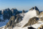
We took our time taking pictures, and Oskar even broke out his hacky sack for some summit action. We could just barely make out the Teton Range some 70 miles to the northwest.


I could have stayed up on that warm summit for a long time, but eventually we had to retrace our steps. Out of an abundance of caution Jake belayed us down some of the steeper snow, and before we knew it, we were back in the boulder fields in the Dinwoody Creek headwaters.

We returned to camp tired but totally psyched about our accomplishment. We were back at camp pretty early in the day and had a decision to make, should we pack up and make some headway back to the trailhead or stay another night in the high country. After some deliberation, we chose to stay high. It felt great to just lounge about in a dramatic location and revel in the day we had. Plus, we were all able to take naps, and an afternoon thunderstorm rolled in, dropping 20 minutes of hard rain down on our tents. It was a great decision to spend another night at camp.
Day 4: High Camp to Cold Springs
Because of our decision to stay high the previous day we were faced with a longer day on day 4, but we felt up to the challenge of hiking all the way out to the trailhead. We got up at a reasonable hour and were hiking by 7:45 am. I think we were all sad to bid adieu to our awesome high camp.
Our hike was smooth, we all crossed Gannett Creek on the same flimsy log and then all waded through Klondike Creek just as we had on the hike in. The views were still spectacular in the valley, and the climb up to Scenic Pass was manageable. We then just had to lose 2000 feet and cruised in to Cold Springs in time to set up our tents and build a big fire in the established fire ring. Jake was even able to get enough connection to listen to some of the Mariner game as we sat around the fire and reminisced on a great trip.


Overall, the hike out was long (over 14 miles), but not exceedingly difficult, and I wouldn’t trade our second night at high camp for a slightly shorter day 4.
Day 5: Back to Crowheart
The next morning, the shuttle came back for us, ferrying new climbers and adventurers up to the trailhead in the process. It was hard that we had to say goodbye to Jake, who now felt like a friend, as he was literally turning around and heading back out for another guided Gannett attempt (what a hero!). We rode in the back of the car with Oskar, bouncing our way down the rocky slopes to Crowheart. It felt equally sad to say goodbye to Oskar as we all went our separate ways. I have nothing but good things to say about those guys and our experience with MAG.
My dad and I then continued our road trip back to Seattle and will never forget our climb of Gannett Peak.
